


Pioneer Canyon
Black Copper Canyon
Placer
Creek Canyon

![]()
![]()
![]()
One of the most astonishing engineering feats of the early West was undertaken near Elizabethtown. Shortly after the rush to E'town gold fields in 1867, miners realized that vast amounts of water were needed to mine profitably the deep placer gravels on the west flank of Baldy Mountain. Due to the lack of water, many of the richest claims could only be worked a few months of the year. A consortium of interested parties promptly contacted Capt. N.S. Davis, a U.S. Army engineer, to locate and evaluate potential water sources for the hydraulic mining operations. Davis concluded that it would be possible to divert the headwaters of the Red River, 11 miles to the west, to the placer fields. By December 1867, The Moreno Water and Mining Company had been organized. The owners were Lucien B. Maxwell, William Kroenig, W.H. Moore, Capt. N.S. Davis, Col. V.S. Shelby, John Dold and M. Bloomfield. A route was surveyed, and work commenced on 12 May 1868. Incredibly, by 13 November, the project was nearly completed, at a cost of only $280,000.
All work was done by hand, and employment peaked at 420 men. The ditch itself attained a length of 41 miles, 660 ft. although the airline distance to the end was only 11 miles due to the mountainous terrain and the fact that the ditch would have to contour around the north end of the Moreno Valley. For over three miles of this distance, aqueducts and side hill flumes had to be constructed. The longest aqueduct spanned 2376 ft. across a canyon near Red River Pass at an elevation of 79 ft. above the creek bed. Elsewhere, along 5 miles of its length, the ditch was blasted into bedrock, in places to a depth of 10 ft. In places, it was necessary to attach the flume to the vertical cliffs. For the first 12 miles, along which the ditch dropped approximately 1 ft/mile, the flume was 2.5 ft wide at the bottom, 5.5 ft wide at the top and 2 ft deep. Along the remaining 29 miles, where the grade was 4 ft/mile, the flume was 4 ft wide at the bottom, 7 ft wide at the top and 2 ft deep.
The ditch tapped the headwaters of the Red River at three lakes: Ditch Lake #1 (now known as Horseshoe Lake), Ditch Lake #2 (Lost Lake) and Ditch Lake #3 (Middle Fork Lake). Approximately 8 miles of branch flume connected these lakes with the Big Ditch. The ditch was designed to divert 600 miners-inches of water under 5 inches of pressure (in New Mexico, 1 cubic ft per second =50 miners-inches; so 600 miner-inches approximately equal 720 cubic ft per min or 7.65 million gallons per day).
![]()
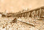
Big Ditch Flume
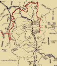
Big Ditch Map
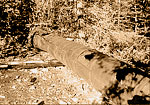
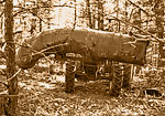
Flume on Ground
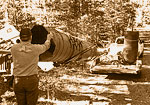
Moving Flume Remains
Moving the Flume
